
TrailPeople

Remembering Randy Anderson
Randy Anderson died peacefully in February 2022, surrounded by loved ones. Randy’s legacy of trail planning, design, and stewardship lives on through the many projects he worked on throughout California in his 40+ years of practice. From the Pacific Crest Trail, to the California Coastal Trail, and every region between, he was able to support access to some of the most treasured and beautiful parts of this state.
And the work that Randy began at TrailPeople continues with Zander Westbrook Design, where we continue to work on projects that he championed: from the completion of the Point Pinos Coastal Trail and the Delta Trail Master Plan, to the advancement of the Napa Valley Vine Trail, Randy's work will inspire and guide our projects for years to come.
Projects
-
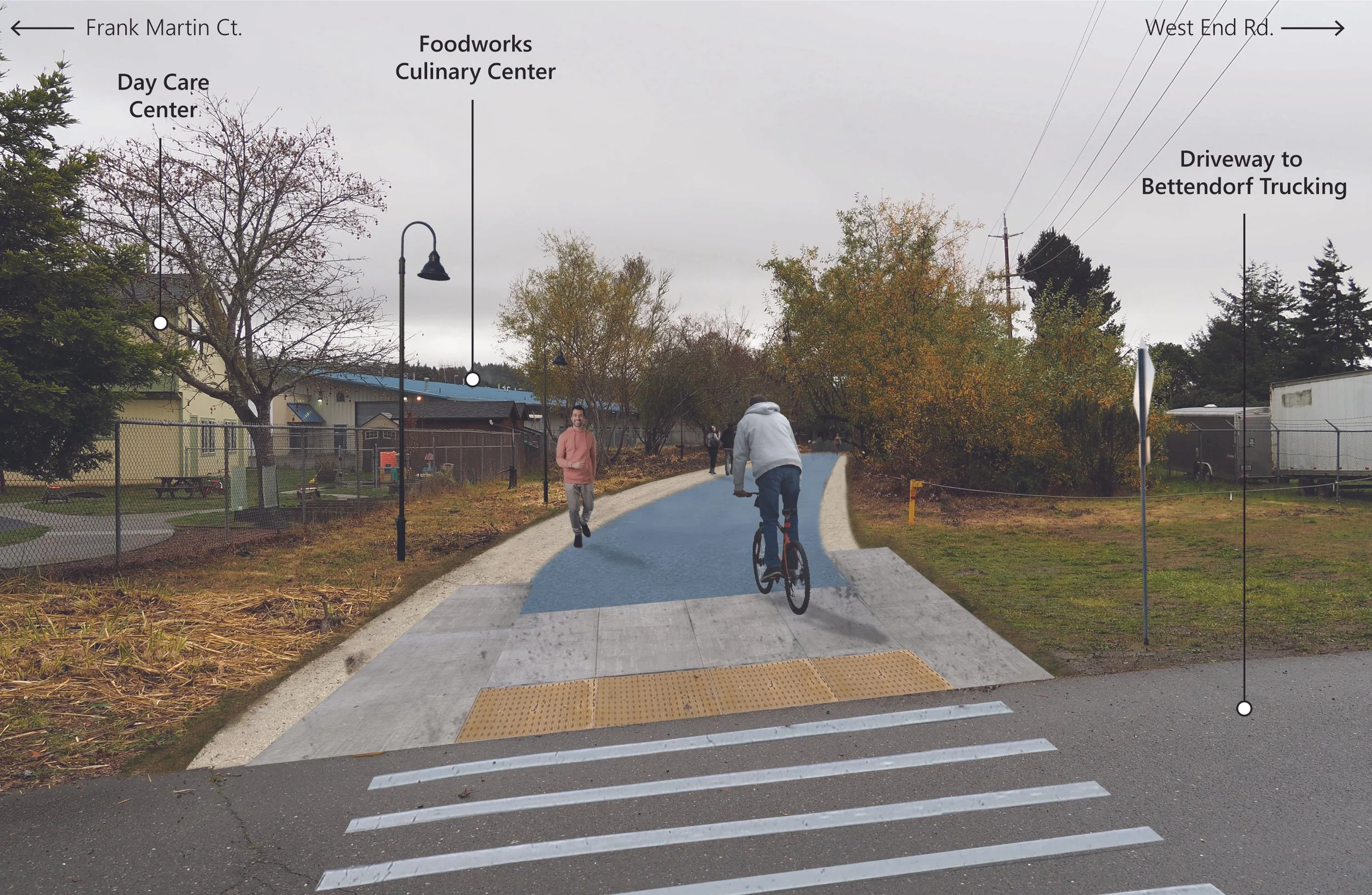
![Rendering of a crosswalk and trail with a biker and pedestrian]()
Annie & Mary Trail - Arcata
Arcata, CA
Feasibility planning and design of construction documents for a major rail-trail in Arcata, CA.
-
![Arroyo Mocho trail - a sidewalk adjacent to a river causeway with golden grass growing on the trail shoulder]()
Arroyo Mocho / Iron Horse Trail
Pleasanton, CA
TrailPeople supported Cal Engineering & Geology with analysis and design recommendations for connections between the Iron Horse Trail and Arroyo Mocho Trail in central Pleasanton.
-
![Rendering of the Annie & Mary trail with two bikers and two pedestrians on a wide trail next to a road, separated by a line of trees]()
Annie & Mary Trail - Blue Lake
Blue Lake, CA
TrailPeople prepared analyses, maps and plans to define and detail a segment of this regional rail-trail within the small city of Blue Lake.
-
![A man stands on a sloping hill with a clipboard, recording data in the field]()
Bob Middagh Trail
Marin County, CA
Marin County Parks retained TrailPeople, supported by Cal Engineering & Geology, to study the feasibility and design to realign or reconfigure trails in the Alto Bowl Open Space to improve their sustainability and potential for multi-use.
-
![People strolling on a path on a clear day near the water in Big Break Regional Park]()
Great Delta Trail Master Plan
San Francisco Bay Area and Sacramento, CA
5-county plan to guide the future of the Delta Trail - connecting the San Francisco Bay to Sacramento.
-
![Map of Fremont, CA showing trails in the area]()
Fremont Trails Strategy Plan
Fremont, CA
A city-wide plan to guide the transportation planning, project development, and implementation of trails in the City of Fremont.
-
![Map of the Fortuna Area in Humboldt County, CA. Bike and pedestrian networks are highlighted]()
Fortuna Highway 101 Complete Streets Study
Fortuna, CA
TrailPeople provided analysis of opportunities and constraints and studies and designs for bicycle and pedestrian facilities, entryway monuments and elements, wayfinding signs, and landscaping for the 12th St./Riverwalk Drive and Kenmar Drive interchanges in the scenic City of Fortuna in Humboldt County.
-
![Section and rendering of a new road plan with a central two-way turn lane, bike lanes on either side, improved angled parking, and 2 vehicle lanes]()
Highway 9 - San Lorenzo Valley Complete Streets Plan
Santa Cruz County, CA
TrailPeople and Kimley-Horn worked with the Santa Cruz Regional Transportation Commission to conduct extensive public and stakeholder outreach and prepare a “complete streets” plan for a 10-mile section of Highway 9 through the San Lorenzo Valley that identifies, prioritizes, and supports implementation of the most critical and cost-effective transportation projects.
-
![Rendering of an elevated crossing over a highway with people walking over it]()
Highway 17 Wildlife & Ridge Trail Crossings
Santa Clara County, CA
TrailPeople led a team of engineers and environmental scientists to study and design the best crossings of Highway 17. Local stakeholder agencies, the public, and Caltrans District 4 helped evaluate alternative locations and configurations and develop plans for the preferred wildlife and trail crossings.
-
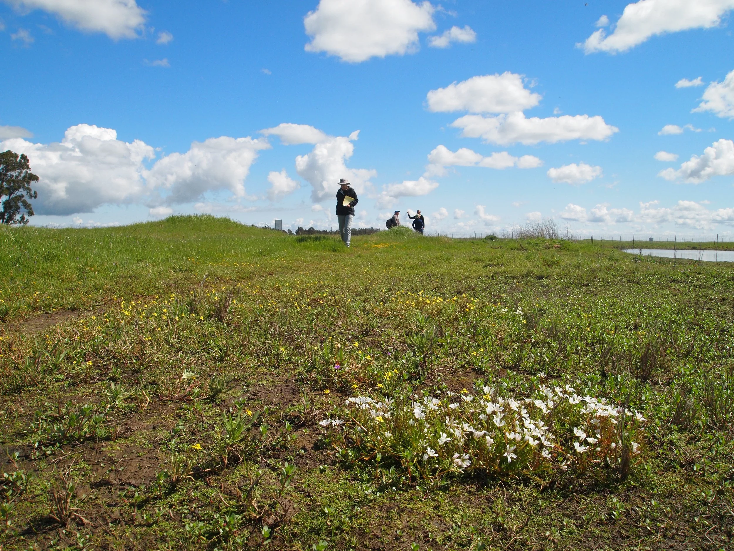
![People standing in a green prairie collecting field data. Yellow and white wildflowers are all across the prairie]()
Jepson Prairie Preserve Visitor Area Improvements
Solano County, CA
TrailPeople worked closely with the docents and staff for this unique vernal pool habitat and native bunchgrass prairie preserve to design upgrades to the visitor's area. The plan includes information signs and kiosk, an accessible self-guided interpretive trail, picnic facilities, restroom, storage, and improved parking.
-
![Looking down a staircase on a trail in Los Altos Hills. The soil is dry and the stairs are sun-dappled]()
Los Altos Pathways
Los Altos, CA
TrailPeople studied the feasibility and cost of creating pedestrian paths along two routes totaling 1.5 miles through residential estate neighborhoods in rolling oak-studded terrain.
-
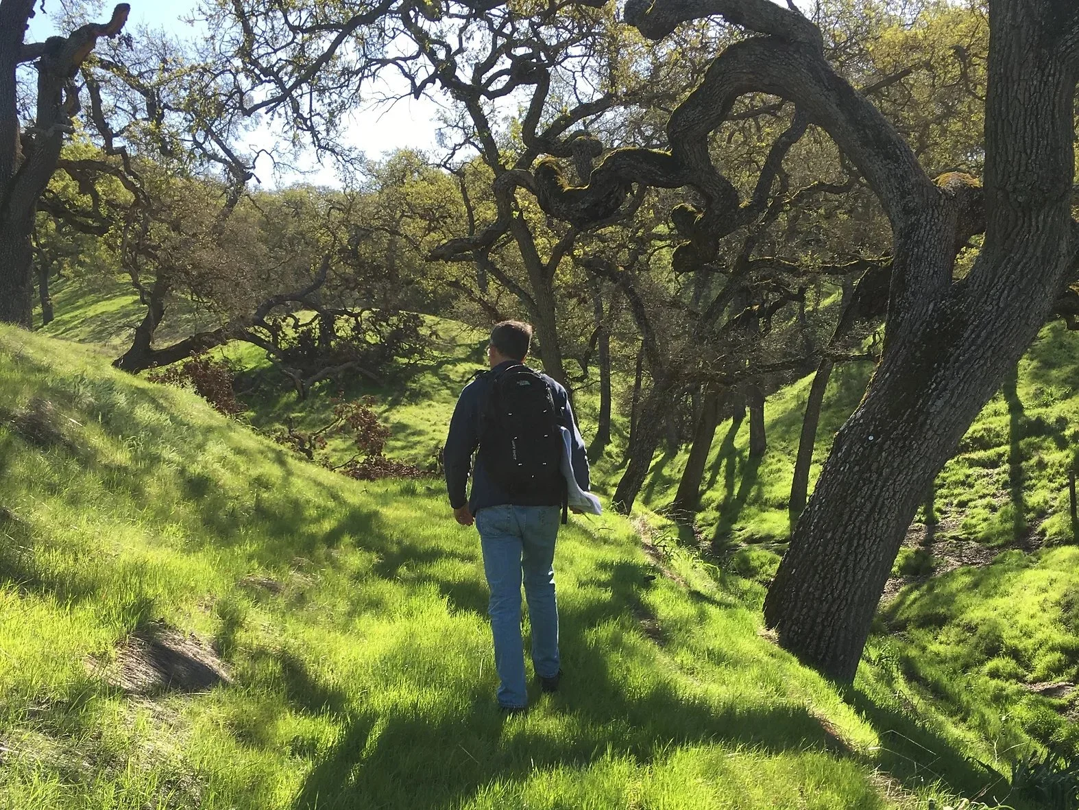
![A man, Randy, walks along a planned trail route through green, grassy hills]()
Lund Ranch Trails
Pleasanton, CA
TrailPeople provided layout and technical assistance for design of a new system recreational trails in the Lund Ranch residential development. TrailPeople coordinated with the project developer, engineering staff, and City of Pleasanton staff to lay out and design the trails. Our staff flagged the preferred alignment and provided GIS layout for the alignment and and CAD drawings for construction details.
-
![Person walking across a crosswalk with a car stopped behind them]()
Mendocino Pedestrian Facility Study
Mendocino, CA
Conducted a comprehensive study to identify and prioritize pedestrian improvement projects in the incorporated and unincorporated regions of Mendocino County.
-
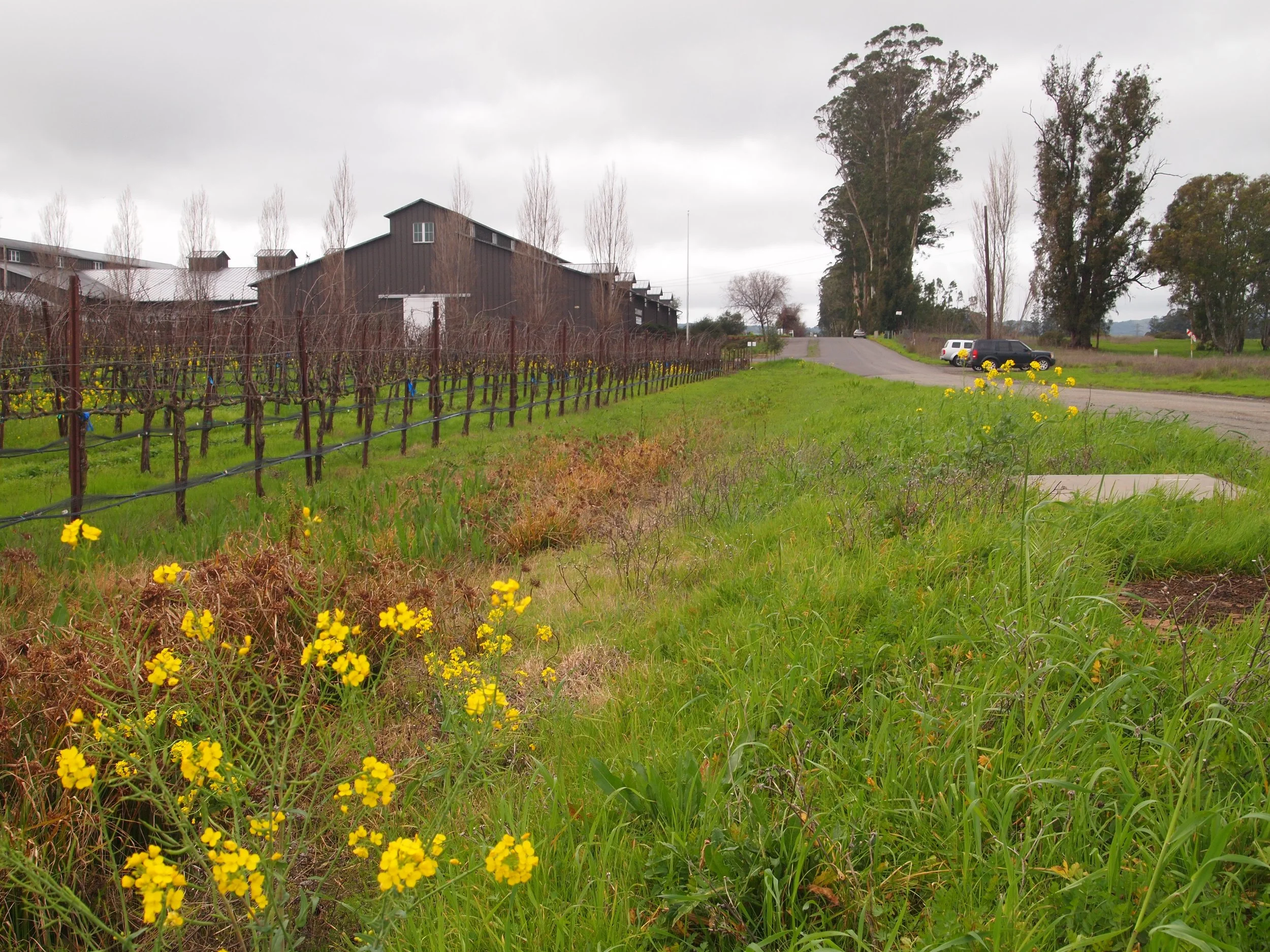
![Railroad tracks next to grape vines in Napa, CA]()
Napa Valley Vine Trail Extension Study
Napa County, CA
TrailPeople studied potential extension routes for the Napa Valley Vine Trail south of Highway 29. Study included research of property owners and plans, field condition assessment, and detailed GIS mapping and analysis.
-
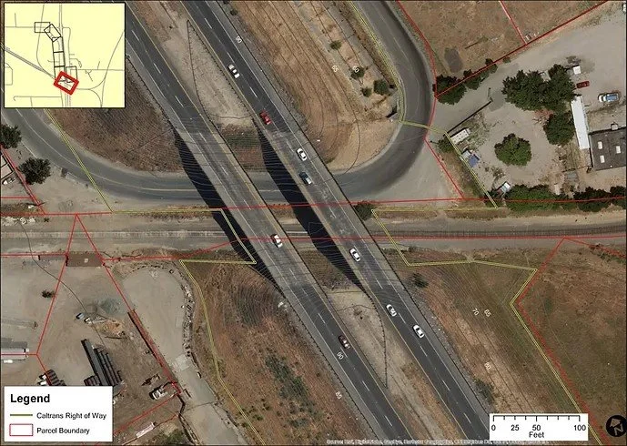
![Detail map of a highway intersection where the Paoli Loop passes under]()
Paoli Loop Vine Trail Alignment Study
American Canyon, CA
TrailPeople documented the conditions and evaluated significant opportunities and constraints along the Paoli Loop, a potential Class 1 trail connection from Green Island Road on the West side of Highway 12 and along the undercrossing of Highway 29.
-
![Rendering of 4 people hiking on a gravel trail through a redwood forest with ferns]()
Pedro Point Coastal Trail
Pacifica, CA
TrailPeople worked with the California Coastal Conservancy to develop trai alignment alternaives for a 1-mile section of the California Coastal Trail from Pacifica, CA to Devil’s Slide Trail.
-
![People at a community meeting look over a map of the city of Plesanton]()
Pleasanton Trails Master Plan
Pleasanton, CA
Led the development of a comprehensive, community-based trail master plan covering the historic, suburban, commercial, and rural portions of Pleasanton.
-
![People walking on a gravel trail adjacent to the pacific ocean with a cypress tree nearby]()
Point Pinos Coastal Trail
Pacific Grove, CA
Planning, design, and construction management for a 0.8 mile, fully accessible segment of the California Coastal Trail, including beach access, parking, habitat restoration, and preparation for adaptive coastal retreat.
-
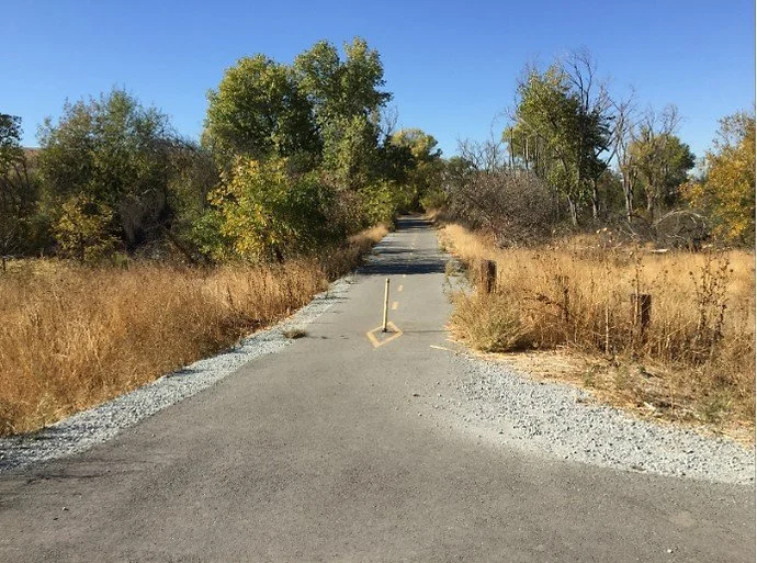
![A paved trail with a bollard in the middle. Green trees and golden grass]()
Santa Teresa Coyote Valley Trail
San Jose, CA
TrailPeople assisted the Bay Area Ridge Trail and Santa Clara Valley Open Space Authority with a trail connection study to connect a section of the Bay Area Ridge Trail in Santa Teresa County Park to the Coyote Creek Trail, as well as a connection to the Coyote Ridge Open Space.
-
![Flowers in front of rows of grape vines near a trail]()
Stanly Lane Bay Trail Extension
Napa, CA
TrailPeople led the design of this regional trail connection to the Napa River for the City of Napa, working with Cal Engineering & Geology. The trail will feature interpretive exhibits of the historic ferry crossing, natural resources, the Bay Trail system, and past and current agricultural land uses.
-
![Map showing proposed route of the Vallejo Bluff Trail over the Benicia Martinez bridge]()
Vallejo Bluff Trail
Vallejo, CA
TrailPeople is led na multi-disciplinary team to prepare technical studies, preliminary designs, environmental documents, construction documents and permits for this important regional trail connection – part of the San Francisco Bay Trail, the Bay Area Ridge Trail, and the California Delta Trail.